Skip to Content
Matterport · Professzionális 3D digitalizálásMatterport · Professional 3D digitizationMatterport · Profesionálna 3D digitalizáciaMatterport · Professionelle 3D-Digitalisierung

Matterport Pro3

Professzionális 3D térdigitalizálás épületekhez, ipari létesítményekhez és nagyobb terekhez.Professional 3D spatial digitization for buildings, industrial facilities and larger spaces.Profesionálna 3D digitalizácia budov, priemyselných objektov a väčších priestorov.Professionelle 3D-Erfassung für Gebäude, Industrieanlagen und größere Räume.

A Matterport Pro3 nagy pontosságú LiDAR technológiát és professzionális képalkotást kombinál, így beltéri és kültéri környezetekből is részletes, interaktív digitális iker készíthető.Matterport Pro3 combines high-accuracy LiDAR technology with professional imaging to create detailed, interactive digital twins of both indoor and outdoor environments.Matterport Pro3 kombinuje presnú technológiu LiDAR s profesionálnym snímaním obrazu. Umožňuje vytvárať podrobné interaktívne digitálne dvojčatá interiérov aj exteriérov.Matterport Pro3 kombiniert präzise LiDAR-Technologie mit professioneller Bildgebung. So entstehen detaillierte, interaktive digitale Zwillinge von Innen- und Außenbereichen.

Használható állapotfelméréshez, építészeti dokumentációhoz, létesítményüzemeltetéshez, ingatlanbemutatáshoz és BIM munkafolyamatok támogatásához.It can be used for condition surveys, architectural documentation, facility management, property presentation and support for BIM workflows.Využíva sa na dokumentáciu stavu, stavebnú dokumentáciu, správu budov, prezentáciu nehnuteľností a podporu pracovných postupov BIM.Geeignet für Zustandsaufnahmen, Baudokumentation, Gebäudemanagement, Immobilienpräsentationen und zur Unterstützung von BIM-Prozessen.
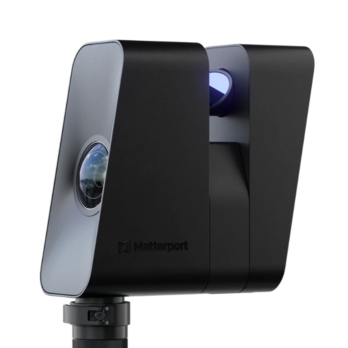
Matterport Pro3 professzionális 3D LiDAR kamera
LiDAR Professzionális 3D térdigitalizálásProfessional 3D digitizationProfesionálna 3D digitalizáciaProfessionelle 3D-Digitalisierung
100 m Maximális mérési tartományMaximum measurement rangeMaximálny merací dosahMaximale Messreichweite
<20 mp Szkennelési idő pozíciónkéntScan time per positionČas skenovania na jedno stanoviskoScanzeit pro Standpunkt
Beltér + kültérIndoor + outdoorInteriér aj exteriérInnen- und Außenbereich Sokoldalú felhasználásVersatile useVšestranné využitieVielseitige Einsatzmöglichkeiten
Felhasználási területekApplicationsOblasti využitiaAnwendungsbereiche

Hol használható a Matterport Pro3?Where can Matterport Pro3 be used?Kde možno využiť Matterport Pro3?Wo kann Matterport Pro3 eingesetzt werden?

A Matterport Pro3 nem egyszerű panorámakamera. A vizuális tartalom és a térbeli adatok együttes rögzítésével számos szakmai munkafolyamatot képes támogatni.Matterport Pro3 is more than a panoramic camera. By capturing visual content and spatial data together, it can support a wide range of professional workflows.Matterport Pro3 nie je len panoramatická kamera. Súčasným snímaním obrazu a priestorových údajov podporuje širokú škálu odborných pracovných postupov.Matterport Pro3 ist mehr als eine Panoramakamera. Durch die gemeinsame Erfassung von Bild- und Raumdaten unterstützt sie zahlreiche professionelle Arbeitsabläufe.

01

Ipari létesítményekIndustrial facilitiesPriemyselné objektyIndustrieanlagen

Gyárak, üzemcsarnokok, raktárak, gépészeti terek és logisztikai központok digitális dokumentálása.Digital documentation of factories, production halls, warehouses, mechanical spaces and logistics centers.Digitálna dokumentácia tovární, výrobných hál, skladov, technických priestorov a logistických centier.Digitale Dokumentation von Fabriken, Produktionshallen, Lagerhäusern, Technikräumen und Logistikzentren.

02

Építészet és BIMArchitecture and BIMArchitektúra a BIMArchitektur und BIM

Meglévő épületek állapotának digitalizálása felújítás, átalakítás és BIM-modellezés előkészítéséhez.Digitization of existing building conditions to support renovation, refurbishment and preparation for BIM modeling.Digitalizácia existujúceho stavu budov ako podklad na rekonštrukciu, prestavbu a prípravu BIM modelovania.Digitalisierung des Bestands von Gebäuden als Grundlage für Sanierungen, Umbauten und die Vorbereitung der BIM-Modellierung.

03

LétesítményüzemeltetésFacility managementSpráva budovFacility Management

Épületek és műszaki területek távoli bejárása, dokumentációja és egyszerűbb kommunikációja.Remote walkthrough, documentation and easier communication for buildings and technical areas.Vzdialené virtuálne prehliadky, dokumentácia a jednoduchšia komunikácia o budovách a technických priestoroch.Virtuelle Begehungen, Dokumentation und einfachere Abstimmung für Gebäude und technische Bereiche.

04

IngatlanbemutatásProperty presentationPrezentácia nehnuteľnostíImmobilienpräsentation

Irodák, szállodák, bemutatótermek, kereskedelmi ingatlanok és különleges épületek interaktív bemutatása.Interactive presentation of offices, hotels, showrooms, commercial properties and distinctive buildings.Interaktívna prezentácia kancelárií, hotelov, showroomov, komerčných nehnuteľností a výnimočných budov.Interaktive Präsentation von Büros, Hotels, Showrooms, Gewerbeimmobilien und besonderen Gebäuden.

05

Műemlékek és örökségvédelemHeritage and conservationPamiatky a kultúrne dedičstvoDenkmäler und Kulturerbe

Templomok, történelmi épületek és kulturális helyszínek digitális állapotának dokumentálása.Digital documentation of the condition of churches, historic buildings and cultural sites.Digitálna dokumentácia stavu kostolov, historických budov a kultúrnych lokalít.Digitale Zustandsdokumentation von Kirchen, historischen Gebäuden und Kulturstätten.

06

Építési dokumentációConstruction documentationStavebná dokumentáciaBaudokumentation

Építési projektek egyes állapotainak rögzítése, összehasonlítható vizuális dokumentáció készítése.Recording different stages of construction projects and creating comparable visual documentation.Zachytávanie jednotlivých etáp stavebných projektov a tvorba porovnateľnej vizuálnej dokumentácie.Erfassung verschiedener Bauphasen und Erstellung vergleichbarer visueller Dokumentationen.

Digitális ikerDigital twinDigitálne dvojčaDigitaler Zwilling

A valós térből interaktív digitális környezetFrom real space to an interactive digital environmentOd reálneho priestoru k interaktívnemu digitálnemu prostrediuVom realen Raum zur interaktiven digitalen Umgebung

A Matterport Pro3-mal végzett felmérés során a tér vizuális és geometriai információi egyetlen digitális környezetben jeleníthetők meg.During a Matterport Pro3 survey, the visual and geometric information of a space can be presented within a single digital environment.Pri zameraní pomocou Matterport Pro3 sa vizuálne a geometrické informácie o priestore spájajú do jedného digitálneho prostredia.Bei einer Erfassung mit Matterport Pro3 werden die visuellen und geometrischen Informationen eines Raums in einer gemeinsamen digitalen Umgebung dargestellt.

A létrejövő digitális iker böngészőből elérhető, megosztható, távolról bejárható, és számos további dokumentációs vagy modellezési munkafolyamat kiindulópontja lehet.The resulting digital twin can be accessed in a browser, shared and explored remotely, and can serve as a starting point for further documentation or modeling workflows.Výsledné digitálne dvojča je prístupné v prehliadači, možno ho zdieľať a prechádzať na diaľku. Môže slúžiť aj ako základ ďalšej dokumentácie a modelovania.Der entstandene digitale Zwilling ist im Browser zugänglich, teilbar und aus der Ferne begehbar. Er kann als Grundlage für weitere Dokumentations- und Modellierungsprozesse dienen.

01 Helyszíni felmérésOn-site surveyZameranie na miesteErfassung vor Ort A helyszín rendszeres szkennelési pontokból történő digitalizálása.Digitizing the site from systematically positioned scan points.Digitalizácia lokality zo systematicky rozmiestnených skenovacích stanovísk.Digitalisierung des Standorts von systematisch angeordneten Scanpositionen aus.
02 3D adatfeldolgozás3D data processingSpracovanie 3D údajov3D-Datenverarbeitung A rögzített térbeli és vizuális információk feldolgozása.Processing the captured spatial and visual information.Spracovanie zaznamenaných priestorových a vizuálnych informácií.Verarbeitung der erfassten räumlichen und visuellen Informationen.
03 Digitális ikerDigital twinDigitálne dvojčaDigitaler Zwilling Interaktív, böngészőből megnyitható virtuális tér.Interactive virtual space accessible from a web browser.Interaktívny virtuálny priestor dostupný vo webovom prehliadači.Interaktiver virtueller Raum, der im Browser geöffnet werden kann.
04 További felhasználásFurther useĎalšie využitieWeiterverwendung BIM, dokumentáció, távoli bejárás vagy vizuális bemutatás.BIM, documentation, remote walkthrough or visual presentation.BIM, dokumentácia, virtuálna prehliadka alebo vizuálna prezentácia.BIM, Dokumentation, virtuelle Begehung oder visuelle Präsentation.
TechnológiaTechnologyTechnológiaTechnologie

Miért Matterport Pro3?Why Matterport Pro3?Prečo Matterport Pro3?Warum Matterport Pro3?

A Pro3 a gyors helyszíni adatgyűjtést és az interaktív 3D megjelenítést egyetlen munkafolyamatban kapcsolja össze.Pro3 combines fast on-site data capture with interactive 3D visualization in a single workflow.Pro3 spája rýchly zber údajov priamo na mieste s interaktívnym 3D zobrazením v jednom pracovnom postupe.Pro3 verbindet schnelle Datenerfassung vor Ort mit interaktiver 3D-Darstellung in einem einzigen Arbeitsablauf.

LiDAR technológiaLiDAR technologyTechnológia LiDARLiDAR-Technologie

Aktív lézeres távolságmérés a környezet térbeli geometriájának rögzítéséhez.Active laser distance measurement for capturing the spatial geometry of the environment.Aktívne laserové meranie vzdialenosti na zachytenie priestorovej geometrie prostredia.Aktive Laser-Entfernungsmessung zur Erfassung der räumlichen Geometrie der Umgebung.

Beltéri és kültéri használatIndoor and outdoor usePoužitie v interiéri aj exteriériInnen- und Außeneinsatz

A Pro3 nem kizárólag épületeken belül használható, így összetett helyszínek dokumentálására is alkalmas.Pro3 is not limited to indoor use, making it suitable for documenting complex sites as well.Pro3 sa dá používať aj mimo budov, takže je vhodná na dokumentáciu zložitejších lokalít.Pro3 kann auch außerhalb von Gebäuden eingesetzt werden und eignet sich damit für die Dokumentation komplexer Standorte.

Gyors adatgyűjtésFast data captureRýchly zber údajovSchnelle Datenerfassung

A rövid szkennelési idő lehetővé teszi nagyobb területek hatékony digitalizálását.The short scan time enables efficient digitization of larger areas.Krátky čas skenovania umožňuje efektívnu digitalizáciu aj väčších priestorov.Dank kurzer Scanzeit lassen sich auch größere Bereiche effizient digitalisieren.

Nagy mérési távolságLong measurement rangeVeľký merací dosahGroße Messreichweite

A LiDAR rendszer akár nagyobb, nyitott belső terek és külső területek felmérésére is használható.The LiDAR system can also be used to survey larger open indoor spaces and outdoor areas.Systém LiDAR možno využiť aj na meranie väčších otvorených interiérov a vonkajších priestorov.Das LiDAR-System kann auch größere, offene Innenräume und Außenbereiche erfassen.

Távoli bejárásRemote walkthroughVirtuálna prehliadka na diaľkuVirtuelle Begehung

A digitalizált helyszín számítógépről, táblagépről vagy mobiltelefonról is megtekinthető és megosztható.The digitized site can be viewed and shared from a computer, tablet or mobile phone.Digitalizovanú lokalitu možno zobraziť a zdieľať na počítači, tablete aj mobilnom telefóne.Der digitalisierte Standort kann am Computer, Tablet oder Smartphone betrachtet und geteilt werden.

Részletgazdag panorámaképHigh-detail panoramic imageryPanoramatické snímky s množstvom detailovDetailreiche Panoramabilder

A 134,2 MP-es kimeneti panoráma a geometriai adatok mellett az épület vizuális részleteit is megörökíti.The 134.2 MP output panorama captures the building’s visual details alongside its geometric data.Výstupná panoráma s rozlíšením 134,2 MP zachytáva popri geometrických údajoch aj vizuálne detaily budovy.Das 134,2-MP-Ausgabepanorama erfasst neben den Geometriedaten auch die visuellen Details des Gebäudes.

Műszaki adatokTechnical specificationsTechnické údajeTechnische Daten

Matterport Pro3 – specifikációMatterport Pro3 – specificationsMatterport Pro3 – technické údajeMatterport Pro3 – technische Daten

Professzionális LiDAR-technológia nagy felbontású képalkotással beltéri és kültéri 3D digitalizáláshoz.Professional LiDAR technology with high-resolution imaging for indoor and outdoor 3D digitization.Profesionálna technológia LiDAR so snímaním obrazu vo vysokom rozlíšení na 3D digitalizáciu interiérov aj exteriérov.Professionelle LiDAR-Technologie mit hochauflösender Bildgebung für die 3D-Digitalisierung im Innen- und Außenbereich.

MélységérzékelésDepth sensingSnímanie hĺbkyTiefenerfassungLiDAR
LézerosztályLaser classTrieda laseraLaserklasse1. osztály (IEC 60825-1:2014)Class 1 (IEC 60825-1:2014)Trieda 1 (IEC 60825-1:2014)Klasse 1 (IEC 60825-1:2014)
HullámhosszWavelengthVlnová dĺžkaWellenlänge904 nm
PontosságAccuracyPresnosťGenauigkeit±20 mm 10 méteren±20 mm at 10 m±20 mm vo vzdialenosti 10 m±20 mm bei 10 m
LátómezőField of viewZorné poleSichtfeld360° vízszintesen / 295° függőlegesen360° horizontal / 295° vertical360° horizontálne / 295° vertikálne360° horizontal / 295° vertikal
Mélységi felbontásDepth resolutionRozlíšenie hĺbkových údajovPunktauflösung100 000 pont/másodperc; akár 1,5 millió pont szkennelésenként100,000 points/second; up to 1.5 million points per scan100 000 bodov za sekundu; až 1,5 milióna bodov na jeden sken100.000 Punkte/Sekunde; bis zu 1,5 Millionen Punkte pro Scan
Mérési tartományMeasurement rangeMerací rozsahMessbereich0,5 m-től akár 100 m-ig; a kiterjesztett tartomány kizárólag E57-adatokban érhető el. A feldolgozott Matterport-modelleknél jellemzően 20 m/szkennelési pont használható.From 0.5 m up to 100 m; the extended range is available only in E57 data. Processed Matterport models typically use up to 20 m per scan position.Od 0,5 m do 100 m; rozšírený dosah je dostupný iba v údajoch E57. Spracované modely Matterport bežne využívajú dosah do 20 m na jedno skenovacie stanovisko.Von 0,5 m bis zu 100 m; der erweiterte Bereich ist ausschließlich in E57-Daten verfügbar. Verarbeitete Matterport-Modelle nutzen üblicherweise bis zu 20 m je Scanposition.
Szkennelési időScan timeČas skenovaniaScanzeitKevesebb mint 20 másodperc pozíciónkéntLess than 20 seconds per positionMenej ako 20 sekúnd na jedno stanoviskoWeniger als 20 Sekunden pro Standpunkt
Kimeneti panorámaOutput panoramaVýstupná panorámaAusgabepanorama134,2 MP
HDR-felvételekHDR captureSnímanie HDRHDR-Aufnahmen5 expozíció HDR-képkockánként5 exposures per HDR frame5 expozícií na jednu snímku HDR5 Belichtungen pro HDR-Bild
KezelésOperationOvládanieBedienungMatterport Capture alkalmazás kompatibilis Apple vagy Android készülékenMatterport Capture app on a compatible Apple or Android deviceAplikácia Matterport Capture na kompatibilnom zariadení Apple alebo AndroidMatterport Capture App auf einem kompatiblen Apple- oder Android-Gerät
TömegWeightHmotnosťGewicht2,2 kg
MéretDimensionsRozmeryAbmessungen181 × 161,4 × 76 mm
AkkumulátorBatteryBatériaAkkuTöbb mint 220 egymást követő szkennelés ideális tesztkörülmények közöttMore than 220 consecutive scans under ideal test conditionsViac ako 220 po sebe nasledujúcich skenov za ideálnych testovacích podmienokMehr als 220 aufeinanderfolgende Scans unter idealen Testbedingungen
VédettségIngress protectionStupeň krytiaSchutzartIP43
Működési hőmérsékletOperating temperaturePrevádzková teplotaBetriebstemperatur0–40 °C
Fontos:Important:Dôležité:Wichtig:a 100 méteres maximális LiDAR-mérési tartomány az E57-fájlokban elérhető kiterjesztett tartományra vonatkozik, nem jelenti azt, hogy a virtuális sétában 100 méteres távolságból minden részlet mérhető. A kamera nem helyettesíti a hitelesített geodéziai felmérést.the 100 m maximum LiDAR measurement range refers to the extended range available in E57 files; it does not mean that every detail in the virtual tour is measurable from 100 m away. The camera does not replace a certified geodetic survey.Maximálny merací dosah LiDAR 100 m sa vzťahuje na rozšírený rozsah dostupný v súboroch E57. Neznamená to, že vo virtuálnej prehliadke možno zo vzdialenosti 100 m odmerať každý detail. Kamera nenahrádza autorizované geodetické meranie.Die maximale LiDAR-Messreichweite von 100 m bezieht sich auf den erweiterten Bereich in E57-Dateien. Dies bedeutet nicht, dass in einem virtuellen Rundgang aus 100 m Entfernung jedes Detail messbar ist. Die Kamera ersetzt keine amtlich anerkannte geodätische Vermessung.

Gyártói termékinformációk és specifikációk →Manufacturer product information and specifications →Produktové informácie a technické údaje výrobcu →Produktinformationen und technische Daten des Herstellers →

Kétféle megoldásTwo ways to work with Pro3Dve možnostiZwei Möglichkeiten

Saját Matterport Pro3 vagy 3D felmérés szolgáltatásként?Own a Matterport Pro3 or order 3D surveying as a service?Vlastná Matterport Pro3 alebo 3D zameranie ako služba?Eigene Matterport Pro3 oder 3D-Vermessung als Dienstleistung?

A rendszer iránt érdeklődő vállalkozásoknak termékbeszerzésben, az egyszeri vagy projektalapú igényekhez helyszíni 3D felméréssel tudunk segíteni.For companies interested in the system, we can assist with purchasing the equipment, while one-off or project-based needs can be handled through on-site 3D surveying as a service.Firmám, ktoré sa zaujímajú o systém, pomôžeme s obstaraním zariadenia. Pri jednorazových alebo projektových potrebách ponúkame 3D zameranie priamo na mieste.Wir unterstützen Unternehmen bei der Gerätebeschaffung oder übernehmen für einmalige und projektbezogene Anforderungen die 3D-Erfassung vor Ort.

EszközbeszerzésEquipment purchaseObstaranie zariadeniaGerätebeschaffung

Matterport Pro3 vásárlásaPurchase a Matterport Pro3Kúpa Matterport Pro3Matterport Pro3 kaufen

Rendszeres felmérést végző szakembereknek és vállalkozásoknak, akik saját kamerával szeretnének dolgozni.For professionals and companies carrying out regular surveys and wishing to work with their own camera.Pre odborníkov a firmy, ktoré vykonávajú pravidelné merania a chcú pracovať s vlastnou kamerou.Für Fachleute und Unternehmen, die regelmäßig Vermessungen durchführen und mit einer eigenen Kamera arbeiten möchten.

  • Saját eszköz, saját ütemezésYour own equipment, your own scheduleVlastné zariadenie, vlastný harmonogramEigenes Gerät, eigene Zeitplanung
  • Rendszeresen ismétlődő projektekhezFor recurring projectsNa pravidelne sa opakujúce projektyFür regelmäßig wiederkehrende Projekte
  • Segítség a megfelelő konfiguráció kiválasztásábanHelp choosing the right configurationPomoc s výberom vhodnej konfigurácieUnterstützung bei der Auswahl der passenden Konfiguration
  • Egyedi ajánlat a várható felhasználás alapjánTailored quotation based on expected useIndividuálna ponuka podľa plánovaného využitiaIndividuelles Angebot auf Basis der geplanten Nutzung

Érdekli a Matterport Pro3?Interested in Matterport Pro3?Zaujíma vás Matterport Pro3?Interessieren Sie sich für Matterport Pro3?

Kérjen személyre szabott ajánlatot kamera beszerzésére vagy professzionális 3D felmérésre. Segítünk kiválasztani a projektjéhez megfelelő megoldást.Request a tailored quotation for purchasing a camera or for professional 3D surveying. We will help you choose the right solution for your project.Vyžiadajte si individuálnu cenovú ponuku na kúpu kamery alebo profesionálne 3D zameranie. Pomôžeme vám vybrať vhodné riešenie pre váš projekt.Fordern Sie ein individuelles Angebot für den Kamerakauf oder eine professionelle 3D-Vermessung an. Wir unterstützen Sie bei der Auswahl der passenden Lösung für Ihr Projekt.