Nagy területek
Telephelyek, ipari területek, mezőgazdasági táblák és egyéb kiterjedt helyszínek gyors dokumentálása.
REVERTO-GLOBAL · DRONE DATA COLLECTION AND 3D PROCESSING
With drone surveys, larger areas, buildings, industrial sites, and infrastructures can be captured quickly, in detail, and in a documentable manner.
From the images, an orthophoto, point cloud, 3D model, surface model, or thermal imaging examination material can be prepared as required.
I request a quote How do we work?
A drónos felmérés különösen hasznos ott, ahol a hagyományos helyszíni dokumentálás lassú, költséges vagy nehézkes lenne.
Telephelyek, ipari területek, mezőgazdasági táblák és egyéb kiterjedt helyszínek gyors dokumentálása.
Homlokzatok, tetőszerkezetek és nehezen elérhető részek vizuális és geometriai felmérése.
Napelemparkok, tornyok, csővezetékek és egyéb infrastruktúrák állapotfelmérésének támogatása.
Depóniák, bányák és anyaghalmok geometriai dokumentálása későbbi számításokhoz.
Fotogrammetriai pontfelhő és 3D modell készítése további tervezési vagy modellezési feladatokhoz.
Azonos helyszín ismételt felmérésével az állapotváltozás vagy a projekt előrehaladása visszakövethető.
A kimenet mindig a projekt céljától, a helyszíntől, a repülési feltételektől és a szükséges pontosságtól függ.
RGB drónfelvételekből térben értelmezhető, mérhető és tovább feldolgozható adatok készíthetők.
A projekt igénye szerint további vizsgálatok és adatformátumok is készíthetők vagy előkészíthetők.
Fontos: a drónos fotogrammetria pontossága függ a repülési tervtől, a kamera paramétereitől, a helyszíni viszonyoktól és az illesztési módszertől. Geodéziai pontosságot igénylő munkánál a mérési követelményeket előre egyeztetni kell.
Hőkamerás felvételekkel például napelemparkok és infrastruktúrák vizsgálata támogatható. A termikus adatok segíthetnek a rendellenes mintázatok azonosításában és a célzott helyszíni ellenőrzések előkészítésében.
A pontos repülési tervet és feldolgozási folyamatot mindig a kívánt eredményhez igazítjuk.
Egyeztetjük a helyszínt, a szükséges pontosságot és az elvárt kimenetet.
Megtervezzük a repülést, az átfedéseket, a repülési magasságot és a szükséges szenzorokat.
Elvégezzük a drónos felmérést a szükséges képi és térbeli lefedettséggel.
Elkészítjük a megállapodás szerinti ortofotót, pontfelhőt, modellt vagy riportot.
A pontosság a repülési magasságtól, az átfedéstől, a kamera paramétereitől, a helyszíni viszonyoktól és az illesztési módszertől függ. Geodéziai pontosságot igénylő munkánál ezt előre egyeztetni kell.
Az ortofotó felülnézeti, geometriailag korrigált képi eredmény. A 3D modell térbeli felületet ad, amely több nézőpontból vizsgálható és tovább feldolgozható.
Igen. Megfelelő képi átfedés és fotogrammetriai feldolgozás esetén sűrű pontfelhő készíthető további 3D feldolgozáshoz vagy modellezéshez.
Olyan feladatoknál, ahol a hőmérsékleti eltérések fontos információt adhatnak, például napelemparkok vagy egyes infrastruktúrák vizsgálatánál.
A feldolgozási idő a terület méretétől, a képek számától, a kívánt kimenettől és a szükséges részletességtől függ. A konkrét határidőt az ajánlatban rögzítjük.
A drónos pontfelhő és 3D geometria jó alapot adhat további modellezéshez, de a BIM-modell elkészítése külön feldolgozási feladat.
Drone surveying is especially useful where conventional on-site documentation would be slow, expensive or difficult.
Fast documentation of industrial sites, facilities, agricultural areas and other extensive locations.
Visual and geometric capture of façades, roof structures and hard-to-reach elements.
Support for condition assessment of solar parks, towers, pipelines and other infrastructure.
Geometric documentation of mines, depots and material piles for later calculations.
Photogrammetric point clouds and 3D models for further design or modelling work.
Repeat surveys can make changes or project progress easier to track.
The final deliverable depends on the project goal, site, flight conditions and required accuracy.
RGB drone imagery can be transformed into measurable, spatially interpretable data.
Depending on project needs, further analyses and data preparation can be delivered.
Important: achievable accuracy depends on the flight plan, camera parameters, site conditions and alignment method. Geodetic-grade requirements must be agreed in advance.
Thermal imagery can support inspections of solar parks and infrastructure by helping identify abnormal temperature patterns and guide targeted follow-up checks.
The exact flight and processing workflow is adapted to the required result.
We clarify the site, required accuracy and expected deliverable.
We plan overlap, altitude, flight path and required sensors.
We perform the drone survey with the required visual and spatial coverage.
We prepare the agreed orthophoto, point cloud, model or report.
Accuracy depends on flight height, image overlap, camera settings, site conditions and the alignment method. Geodetic-grade requirements should be agreed in advance.
An orthophoto is a geometrically corrected top-down image, while a 3D model provides spatial geometry that can be inspected from multiple viewpoints.
Yes. With proper image overlap and photogrammetric processing, a dense point cloud can be created for further 3D processing or modelling.
Where temperature differences can provide meaningful information, for example when inspecting solar parks or infrastructure.
Processing time depends on the size of the area, number of images, required output and level of detail.
Drone-derived point clouds and 3D geometry can provide a good basis for further modelling, but BIM creation is a separate workflow.
Die Drohnenvermessung ist besonders dort sinnvoll, wo eine herkömmliche Dokumentation vor Ort langsam, teuer oder schwierig wäre.
Schnelle Dokumentation von Industrieflächen, Betriebsarealen, landwirtschaftlichen Flächen und anderen weitläufigen Standorten.
Visuelle und geometrische Erfassung von Fassaden, Dachkonstruktionen und schwer zugänglichen Bereichen.
Unterstützung der Zustandsbewertung von Solarparks, Türmen, Leitungen und anderer Infrastruktur.
Geometrische Dokumentation von Minen, Depots und Materialhalden für spätere Berechnungen.
Photogrammetrische Punktwolken und 3D-Modelle als Grundlage für weitere Planungs- oder Modellierungsaufgaben.
Wiederholte Befliegungen machen Veränderungen oder Projektfortschritte nachvollziehbar.
Das Endergebnis hängt vom Projektziel, vom Standort, von den Flugbedingungen und von der benötigten Genauigkeit ab.
Aus RGB-Drohnenbildern lassen sich messbare und räumlich interpretierbare Daten erzeugen.
Je nach Projektbedarf können weitere Analysen und Datenaufbereitungen geliefert werden.
Wichtig: die erreichbare Genauigkeit hängt vom Flugplan, den Kameraparametern, den Standortbedingungen und der Ausrichtungsmethode ab. Geodätische Anforderungen müssen vorab abgestimmt werden.
Thermische Aufnahmen können die Inspektion von Solarparks und Infrastruktur unterstützen und helfen, auffällige Temperaturmuster gezielt zu erkennen.
Den genauen Flug- und Verarbeitungsablauf stimmen wir auf das gewünschte Ergebnis ab.
Wir klären Standort, benötigte Genauigkeit und gewünschtes Ergebnis.
Wir planen Überlappung, Flughöhe, Flugweg und benötigte Sensoren.
Wir führen die Drohnenvermessung mit der erforderlichen visuellen und räumlichen Abdeckung durch.
Wir erstellen das vereinbarte Orthofoto, die Punktwolke, das Modell oder den Bericht.
Die Genauigkeit hängt von Flughöhe, Bildüberlappung, Kameraparametern, Standortbedingungen und der Ausrichtungsmethode ab.
Ein Orthofoto ist ein geometrisch korrigiertes Bild in Draufsicht. Ein 3D-Modell liefert eine räumliche Geometrie, die aus verschiedenen Blickwinkeln betrachtet werden kann.
Ja. Bei ausreichender Bildüberlappung und photogrammetrischer Verarbeitung kann eine dichte Punktwolke erzeugt werden.
Wenn Temperaturunterschiede wichtige Informationen liefern können, zum Beispiel bei der Prüfung von Solarparks oder Infrastruktur.
Die Bearbeitungszeit hängt von Flächengröße, Bildanzahl, gewünschtem Ergebnis und Detaillierungsgrad ab.
Punktwolken und 3D-Geometrien können eine gute Grundlage bilden, die BIM-Erstellung selbst ist jedoch ein separater Arbeitsschritt.
Dronové zameranie je obzvlášť užitočné tam, kde by bolo bežné dokumentovanie na mieste pomalé, drahé alebo náročné.
Rýchla dokumentácia priemyselných areálov, prevádzok, poľnohospodárskych plôch a iných rozsiahlych lokalít.
Vizuálne a geometrické zameranie fasád, strešných konštrukcií a ťažko dostupných prvkov.
Podpora hodnotenia stavu solárnych parkov, veží, potrubí a ďalšej infraštruktúry.
Geometrická dokumentácia baní, depónií a materiálových hromád pre následné výpočty.
Fotogrametrické mračno bodov a 3D modely pre ďalšie projektové alebo modelovacie úlohy.
Opakované zameranie rovnakej lokality pomáha sledovať zmeny alebo postup projektu.
Konečný výstup závisí od cieľa projektu, lokality, podmienok letu a požadovanej presnosti.
Z RGB snímok z dronu možno vytvoriť merateľné a priestorovo interpretovateľné dáta.
Podľa potrieb projektu možno dodať aj ďalšie analýzy a prípravu dát.
Dôležité: dosiahnuteľná presnosť závisí od letového plánu, parametrov kamery, podmienok na mieste a použitej metódy zarovnania.
Termálne snímky môžu podporiť kontrolu solárnych parkov a infraštruktúry tým, že pomáhajú odhaliť neštandardné teplotné vzory.
Presný letový a spracovateľský postup prispôsobujeme požadovanému výsledku.
Upresníme lokalitu, potrebnú presnosť a očakávaný výstup.
Naplánujeme prekrytie snímok, výšku letu, trasu a potrebné senzory.
Vykonáme dronové zameranie s potrebným vizuálnym a priestorovým pokrytím.
Pripravíme dohodnuté ortofoto, mračno bodov, model alebo správu.
Presnosť závisí od výšky letu, prekrytia snímok, parametrov kamery, podmienok na mieste a spôsobu zarovnania.
Ortofoto je geometricky korigovaný pohľad zhora. 3D model poskytuje priestorovú geometriu, ktorú možno prezerať z viacerých uhlov.
Áno. Pri dostatočnom prekrytí snímok a vhodnom fotogrametrickom spracovaní možno vytvoriť husté mračno bodov.
Pri úlohách, kde môžu teplotné rozdiely poskytnúť dôležitú informáciu, napríklad pri kontrole solárnych parkov alebo infraštruktúry.
Čas spracovania závisí od veľkosti plochy, počtu snímok, požadovaného výstupu a úrovne detailu.
Mračno bodov a 3D geometria môžu byť dobrým základom pre ďalšie modelovanie, samotné vytvorenie BIM modelu je však samostatný proces.
A drónos felmérés különösen hasznos ott, ahol a hagyományos helyszíni dokumentálás lassú, költséges vagy nehézkes lenne.
Telephelyek, ipari területek, mezőgazdasági táblák és egyéb kiterjedt helyszínek gyors dokumentálása.
Homlokzatok, tetőszerkezetek és nehezen elérhető részek vizuális és geometriai felmérése.
Napelemparkok, tornyok, csővezetékek és egyéb infrastruktúrák állapotfelmérésének támogatása.
Depóniák, bányák és anyaghalmok geometriai dokumentálása későbbi számításokhoz.
Fotogrammetriai pontfelhő és 3D modell készítése további tervezési vagy modellezési feladatokhoz.
Azonos helyszín ismételt felmérésével az állapotváltozás vagy a projekt előrehaladása visszakövethető.
A kimenet mindig a projekt céljától, a helyszíntől, a repülési feltételektől és a szükséges pontosságtól függ.
RGB drónfelvételekből térben értelmezhető, mérhető és tovább feldolgozható adatok készíthetők.
A projekt igénye szerint további vizsgálatok és adatformátumok is készíthetők vagy előkészíthetők.
Fontos: a drónos fotogrammetria pontossága függ a repülési tervtől, a kamera paramétereitől, a helyszíni viszonyoktól és az illesztési módszertől. Geodéziai pontosságot igénylő munkánál a mérési követelményeket előre egyeztetni kell.
Hőkamerás felvételekkel például napelemparkok és infrastruktúrák vizsgálata támogatható. A termikus adatok segíthetnek a rendellenes mintázatok azonosításában és a célzott helyszíni ellenőrzések előkészítésében.
A pontos repülési tervet és feldolgozási folyamatot mindig a kívánt eredményhez igazítjuk.
Egyeztetjük a helyszínt, a szükséges pontosságot és az elvárt kimenetet.
Megtervezzük a repülést, az átfedéseket, a repülési magasságot és a szükséges szenzorokat.
Elvégezzük a drónos felmérést a szükséges képi és térbeli lefedettséggel.
Elkészítjük a megállapodás szerinti ortofotót, pontfelhőt, modellt vagy riportot.
A pontosság a repülési magasságtól, az átfedéstől, a kamera paramétereitől, a helyszíni viszonyoktól és az illesztési módszertől függ. Geodéziai pontosságot igénylő munkánál ezt előre egyeztetni kell.
Az ortofotó felülnézeti, geometriailag korrigált képi eredmény. A 3D modell térbeli felületet ad, amely több nézőpontból vizsgálható és tovább feldolgozható.
Igen. Megfelelő képi átfedés és fotogrammetriai feldolgozás esetén sűrű pontfelhő készíthető további 3D feldolgozáshoz vagy modellezéshez.
Olyan feladatoknál, ahol a hőmérsékleti eltérések fontos információt adhatnak, például napelemparkok vagy egyes infrastruktúrák vizsgálatánál.
A feldolgozási idő a terület méretétől, a képek számától, a kívánt kimenettől és a szükséges részletességtől függ. A konkrét határidőt az ajánlatban rögzítjük.
A drónos pontfelhő és 3D geometria jó alapot adhat további modellezéshez, de a BIM-modell elkészítése külön feldolgozási feladat.
Drone surveying is especially useful where conventional on-site documentation would be slow, expensive or difficult.
Fast documentation of industrial sites, facilities, agricultural areas and other extensive locations.
Visual and geometric capture of façades, roof structures and hard-to-reach elements.
Support for condition assessment of solar parks, towers, pipelines and other infrastructure.
Geometric documentation of mines, depots and material piles for later calculations.
Photogrammetric point clouds and 3D models for further design or modelling work.
Repeat surveys can make changes or project progress easier to track.
The final deliverable depends on the project goal, site, flight conditions and required accuracy.
RGB drone imagery can be transformed into measurable, spatially interpretable data.
Depending on project needs, further analyses and data preparation can be delivered.
Important: achievable accuracy depends on the flight plan, camera parameters, site conditions and alignment method. Geodetic-grade requirements must be agreed in advance.
Thermal imagery can support inspections of solar parks and infrastructure by helping identify abnormal temperature patterns and guide targeted follow-up checks.
The exact flight and processing workflow is adapted to the required result.
We clarify the site, required accuracy and expected deliverable.
We plan overlap, altitude, flight path and required sensors.
We perform the drone survey with the required visual and spatial coverage.
We prepare the agreed orthophoto, point cloud, model or report.
Accuracy depends on flight height, image overlap, camera settings, site conditions and the alignment method. Geodetic-grade requirements should be agreed in advance.
An orthophoto is a geometrically corrected top-down image, while a 3D model provides spatial geometry that can be inspected from multiple viewpoints.
Yes. With proper image overlap and photogrammetric processing, a dense point cloud can be created for further 3D processing or modelling.
Where temperature differences can provide meaningful information, for example when inspecting solar parks or infrastructure.
Processing time depends on the size of the area, number of images, required output and level of detail.
Drone-derived point clouds and 3D geometry can provide a good basis for further modelling, but BIM creation is a separate workflow.
Die Drohnenvermessung ist besonders dort sinnvoll, wo eine herkömmliche Dokumentation vor Ort langsam, teuer oder schwierig wäre.
Schnelle Dokumentation von Industrieflächen, Betriebsarealen, landwirtschaftlichen Flächen und anderen weitläufigen Standorten.
Visuelle und geometrische Erfassung von Fassaden, Dachkonstruktionen und schwer zugänglichen Bereichen.
Unterstützung der Zustandsbewertung von Solarparks, Türmen, Leitungen und anderer Infrastruktur.
Geometrische Dokumentation von Minen, Depots und Materialhalden für spätere Berechnungen.
Photogrammetrische Punktwolken und 3D-Modelle als Grundlage für weitere Planungs- oder Modellierungsaufgaben.
Wiederholte Befliegungen machen Veränderungen oder Projektfortschritte nachvollziehbar.
Das Endergebnis hängt vom Projektziel, vom Standort, von den Flugbedingungen und von der benötigten Genauigkeit ab.
Aus RGB-Drohnenbildern lassen sich messbare und räumlich interpretierbare Daten erzeugen.
Je nach Projektbedarf können weitere Analysen und Datenaufbereitungen geliefert werden.
Wichtig: die erreichbare Genauigkeit hängt vom Flugplan, den Kameraparametern, den Standortbedingungen und der Ausrichtungsmethode ab. Geodätische Anforderungen müssen vorab abgestimmt werden.
Thermische Aufnahmen können die Inspektion von Solarparks und Infrastruktur unterstützen und helfen, auffällige Temperaturmuster gezielt zu erkennen.
Den genauen Flug- und Verarbeitungsablauf stimmen wir auf das gewünschte Ergebnis ab.
Wir klären Standort, benötigte Genauigkeit und gewünschtes Ergebnis.
Wir planen Überlappung, Flughöhe, Flugweg und benötigte Sensoren.
Wir führen die Drohnenvermessung mit der erforderlichen visuellen und räumlichen Abdeckung durch.
Wir erstellen das vereinbarte Orthofoto, die Punktwolke, das Modell oder den Bericht.
Die Genauigkeit hängt von Flughöhe, Bildüberlappung, Kameraparametern, Standortbedingungen und der Ausrichtungsmethode ab.
Ein Orthofoto ist ein geometrisch korrigiertes Bild in Draufsicht. Ein 3D-Modell liefert eine räumliche Geometrie, die aus verschiedenen Blickwinkeln betrachtet werden kann.
Ja. Bei ausreichender Bildüberlappung und photogrammetrischer Verarbeitung kann eine dichte Punktwolke erzeugt werden.
Wenn Temperaturunterschiede wichtige Informationen liefern können, zum Beispiel bei der Prüfung von Solarparks oder Infrastruktur.
Die Bearbeitungszeit hängt von Flächengröße, Bildanzahl, gewünschtem Ergebnis und Detaillierungsgrad ab.
Punktwolken und 3D-Geometrien können eine gute Grundlage bilden, die BIM-Erstellung selbst ist jedoch ein separater Arbeitsschritt.
Dronové zameranie je obzvlášť užitočné tam, kde by bolo bežné dokumentovanie na mieste pomalé, drahé alebo náročné.
Rýchla dokumentácia priemyselných areálov, prevádzok, poľnohospodárskych plôch a iných rozsiahlych lokalít.
Vizuálne a geometrické zameranie fasád, strešných konštrukcií a ťažko dostupných prvkov.
Podpora hodnotenia stavu solárnych parkov, veží, potrubí a ďalšej infraštruktúry.
Geometrická dokumentácia baní, depónií a materiálových hromád pre následné výpočty.
Fotogrametrické mračno bodov a 3D modely pre ďalšie projektové alebo modelovacie úlohy.
Opakované zameranie rovnakej lokality pomáha sledovať zmeny alebo postup projektu.
Konečný výstup závisí od cieľa projektu, lokality, podmienok letu a požadovanej presnosti.
Z RGB snímok z dronu možno vytvoriť merateľné a priestorovo interpretovateľné dáta.
Podľa potrieb projektu možno dodať aj ďalšie analýzy a prípravu dát.
Dôležité: dosiahnuteľná presnosť závisí od letového plánu, parametrov kamery, podmienok na mieste a použitej metódy zarovnania.
Termálne snímky môžu podporiť kontrolu solárnych parkov a infraštruktúry tým, že pomáhajú odhaliť neštandardné teplotné vzory.
Presný letový a spracovateľský postup prispôsobujeme požadovanému výsledku.
Upresníme lokalitu, potrebnú presnosť a očakávaný výstup.
Naplánujeme prekrytie snímok, výšku letu, trasu a potrebné senzory.
Vykonáme dronové zameranie s potrebným vizuálnym a priestorovým pokrytím.
Pripravíme dohodnuté ortofoto, mračno bodov, model alebo správu.
Presnosť závisí od výšky letu, prekrytia snímok, parametrov kamery, podmienok na mieste a spôsobu zarovnania.
Ortofoto je geometricky korigovaný pohľad zhora. 3D model poskytuje priestorovú geometriu, ktorú možno prezerať z viacerých uhlov.
Áno. Pri dostatočnom prekrytí snímok a vhodnom fotogrametrickom spracovaní možno vytvoriť husté mračno bodov.
Pri úlohách, kde môžu teplotné rozdiely poskytnúť dôležitú informáciu, napríklad pri kontrole solárnych parkov alebo infraštruktúry.
Čas spracovania závisí od veľkosti plochy, počtu snímok, požadovaného výstupu a úrovne detailu.
Mračno bodov a 3D geometria môžu byť dobrým základom pre ďalšie modelovanie, samotné vytvorenie BIM modelu je však samostatný proces.
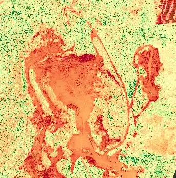
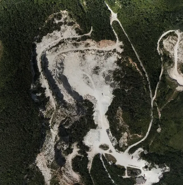
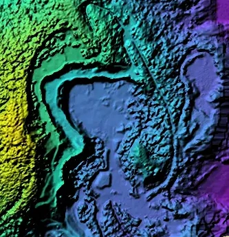
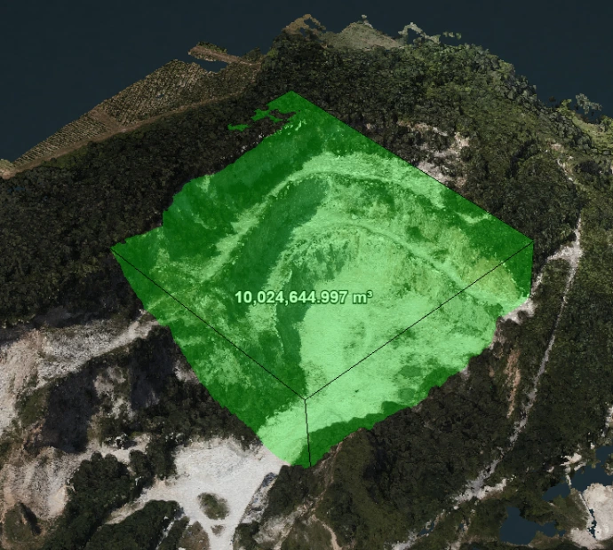
From drone data collection, depending on the project's goal, orthophoto, surface model, point cloud, 3D model, volume calculation, or thermal camera analysis can be produced. The images below show examples from our own surveys and processes.
Orthophoto / orthomosaic
Detailed aerial documentation of a large area
Surface model
Visual representation of terrain and surface variations.
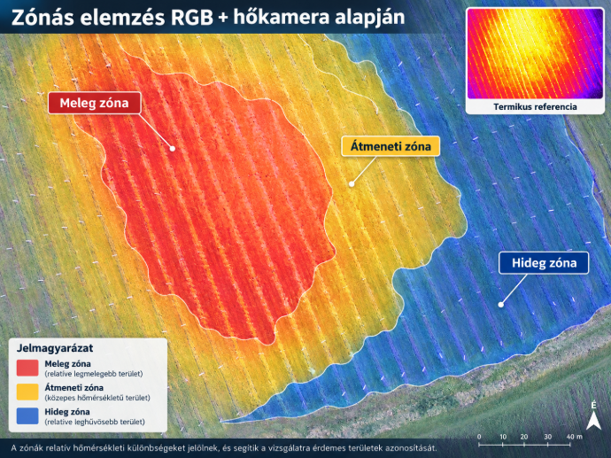
Thermal zonal analysis
Separation of warm, transitional, and cold areas based on thermal data.
Thematic / processed map
Visualization of survey data suitable for further analysis.
Volume calculation
Determining the volume of areas, landfills, or material piles from 3D data.
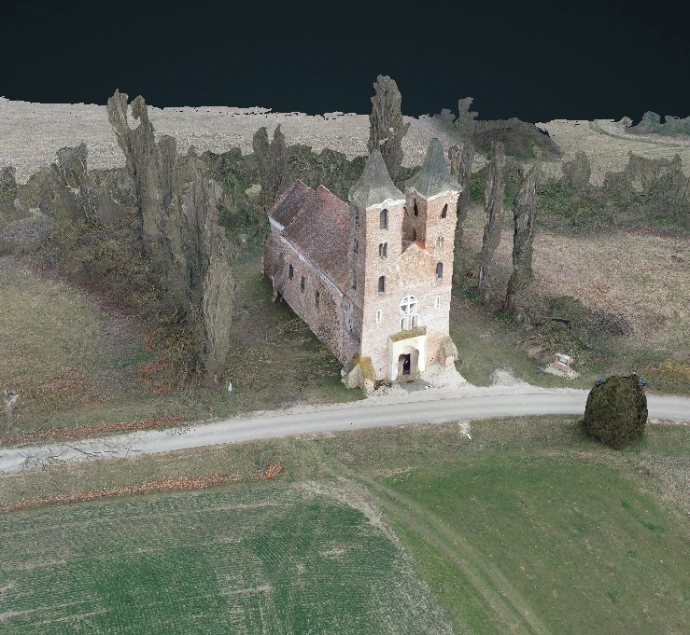
Building and facade survey
Drone documentation of buildings and hard-to-access structural parts for 3D processing.
We use cookies to ensure the proper operation of the website and to improve the user experience. [Cookie Policy]